Water, water, everywhere…

Time 2005 local
Lat N 25° 12.8′
Lon W 70° 44.3′
Nautical miles from Great Harbor, Jost Van Dyke, BVI: 525
Nautical miles to Sandy Hook, NJ: 930

We are, of course, surrounded by undrinkable water, yet we have all the fresh water we need. There are two reason for this.

First, is the huge freshwater tank onboard Harmonie. In the stub of the keel there is a tank with a capacity of about 330 gallons. To put this in perspective, when we sailed my old boat to Hawaii we had two tanks of 40 gallons each. We did not feel especially “water-poor” on that crossing and arrived after 21 days at sea with almost all of one tank untouched. If we were really careful, I figure we could make a full tank of water on Harmonie last for almost 3 months with no input.

In addition to a huge storage tank, we also have a reverse-osmosis unit that uses a high pressure pump run by electricity to make about 10 gallons an hour of freshwater from seawater. Pretty much every day we are in clean ocean water we run the ‘RO’ unit for 30 to 60 minutes while we run the generator. If we are in murky or potentially polluted water we wait. The watermaker has been our only source of water since we left Florida almost 6 months ago, and I don’t think we have ever had less than 150 gallons of water in the tank.

Nothing exciting to report in our sailing today. Winds are a bit lighter, but we continue to make good progress. The winds have begun to clock around from east, to south, and will eventually turn to south west as we circle the Bermuda High. Right now it looks like a landfall on June 8 is most likely, although there is a lot of weather yet to negotiate between here and there.

Posted in Underway | Leave a comment

Almost no better..

Time 1810 local
Lat N 23° 22.0′
Lon W 68° 58.0′
Nautical miles from Great Harbor, Jost Van Dyke, BVI: 378
Nautical miles to Sandy Hook, NJ: 1058

Our progress northward and west ward continue under clear skies with steady, comfortable winds. The wind is from the east-southeast at 15 knots, and we are on a deep broad reach moving at 6.5 knots in nearly flat seas. We are watching the weather models daily to try to pick out the best possible course through the calm spots.

The different models are suggesting different courses–some shorter in distance, but through lighter, and more variable winds. Since making finely scaled predictions is not really something the models are good at, I tend to discount any recommendation based on picking a course through small scale changes in weather forecast several days ahead in favor of a course that might have a bit more distance to it, but more reliable winds that are part of larger scale weather features.

Out here in this part of the open ocean our wildlife count drops dramatically. A few flying fish, and a graceful tropic bird are about our total for the day.

Posted in Underway | Leave a comment

29 May, 2017 17:44

Time 1720 local
Lat N 21° 11.7′
Lon W 67° 31.1′
Nautical miles from Great Harbor, Jost Van Dyke, BVI: 227
Nautical miles to Sandy Hook, NJ: 1203

Today’s sailing varied from exhilaratingly fast, to annoyingly slow. Although any day we cover more than 150 miles, there can be no complaining about!

Last night we were treated to a beautiful light show in the distance as thunderstorm built up over the mountains of Puerto Rico.

We had a couple of typical tradewind squalls go over us this afternoon. They followed they typical pattern, ahead of the squall the winds are reenforced, and blow harder, while behind them the winds are light and fluky. Right now the skies have cleared, and the wind has stabilized again, so we are back on track. Not the 8.5 knots we were doing earlier, but a steady 6.

The weather routing software has us continuing to move west to avoid the very light airs that are over the straight line course. We’ll probably need to get as far north as central Florida before we make a final turn north.

Posted in Underway | Leave a comment

28 May, 2017 18:35

Time 18:15 local
Lat N 19° 09.3′
Lon W 65° 35.7′
Nautical miles from Great Harbor, Jost Van Dyke, BVI: 64.3
Nautical miles to Sandy Hook, NJ: 1350

We are off to a fast start, putting miles under the keel faster than predicted. This is tradewind sailing at its best. We are heading Northwest on a fast and comfortable beam reach. Boat speed is running at almost 8 knots in 14 to 17 knots of wind with a gentle sea. It looks like there are some rain clouds coming up behind us, but nothing serious in the forecast. If the weather model are to be trusted, we should see stable conditions like this for several days.

We are now sailing over the Puerto Rico trench, one of the deepest spots in the ocean. According to our chart there are five miles of water under us right now. We passed a large school of tuna feeding, made apparent by the sudden crowd of birds that appeared out of nowhere. Unfortunately they were to windward of us and we weren’t able to get close enough to put some fresh sushi in the boat.

Close to the islands there is so much saragossum weed in the water, fishing trolled lines is an exercise in frustration. It has thinned out enough now, I expect to have lines in the water tomorrow.

Posted in Underway | Leave a comment

Anchors Aweigh!

Great Harbor, Jost Van Dyke, BVI

All that is left is to stow the dinghy, droop the mooring line, and we are off.  We checked out of the British Virgin Islands yesterday afternoon, and paid the customs officer our $10 departure tax.  In a great example of the “logic” of bureaucracies everywhere, we start at the Customs desk.  Pay our money, and get a form stamped–in triplicate.  Whenever you deal with Customs in smaller countries there is always LOTS of stamping!  Peter Sellers could have made a great comedy scene in a Customs office with the proper stamp.

We are told we have to take our paperwork to Immigration to finish.  Where is Immigration?  The next desk over, of course. What does Immigration do?  He takes the form Customs just stamped, and wishes us a nice day. That’s it. I am sure this makes sense to someone, but in a country with virtually no unemployment it can’t be justified by a make-work rationale.

A last minute check of the weather, shows a great forecast. No significant issues predicted all the way north.  The only decision we have to make is how far west of the straight line course between here and New Jersey do we sail.  Directly between us and our destination is the “Bermuda High” a semi-permenent fixture of the weather in this part of the Atlantic in the summer.  A large area of dry, clear, weather with bright sunny skies, and  NO wind. Many people chose to just point the boat into the middle of it and use the engine if they stop moving.  We’d prefer to do it the old-fashioned way, and sail around it.  If we enjoyed motoring, we would have bought a motorboat!

The further west we sail, the more likely we are to keep favorable winds, but at the cost of a longer route.  This is a decision we will be reevaluating pretty much every day as we get updated weather information.

Posted in Underway | Leave a comment

Last Minute…

First thing you have to understand: For cruising sailors the word “rushing” means something a bit different than it means to most people with “real” lives.  With that said, we are “rushing” to get everything put together for our next stage.  We have a few things to stow, and then we will be out of the marina here in the morning.  We have a stop in Jost Van Dyke, the next island to the north for tomorrow night.

While in Great Harbor at Jost Van Dyke, we will “clear out” of the British Virgin Islands, completing the process of formally telling the local Customs Service here that we are leaving, and paying our Departure Tax.  Most countries require that you “check out” when you leave.  Once you complete this process they issue you a “Zarpa”,  a piece of paper which the NEXT country you go to wants to see to be sure that you did not run away from you last port under less than honorable circumstances.

Once we complete the formalities,  then we are off.  We have about a nine or ten day passage from Jost Van Dyke to Sandy Hook Bay Marina in New Jersey.  The further north we go, the less predictable the weather gets.  If I believe the weather models, we will see winds varying from less than 1 knot to between 25 to 30.  Nothing scary or troublesome.  It has been a long time since we have had a passage of this length, and we are very much looking forward to it.


Posted in Underway | Leave a comment

Moving On

Our guests of the past week have now taken off for the airport back to their “real lives,” and we are getting ready for the next step in our journey.

Our plan from here is to sail directly from the British Virgin Islands to New Jersey, visit there for a week or two, and then move north to New England.  The initial leg of that trip should be a trip of about 10 to 12 days.  Right now the weather looks pretty stable, so I am not expecting our departure date to be set much by weather conditions.

For this trip at this time of year, the winds are typically very favorable. The models predict the fastest route to be a simple rumb line course, running or reaching almost all the way.  We can hope!

We have a few last minute things we want to pick up that we can not get in the USA that we want to get to make life easier and better, make sure our food stores are ready for two weeks, and we will be off.

A few legal and logistical things to do before we leave.  We have to clear out of customs here in the British Virgin Islands, and pay our departure tax.  We also need to file a “float plan” with the USA customs office so we can take advantage of the (hopefully) quick and easy phone check in when we arrive back in the USA.

Posted in Underway | 1 Comment

Around the BVI

We have been around several spots in the British Virgin Islands over the past few days with our guests, Karen’s friends Bill and Cindy.  Bill is an avid diver and has helped me get the mechanics of using our surface supplied air system worked out.   It does take a bit of time to get it all assembled for a morning’s dive, but once together and running, it works great.

Tonight we are in the Virgin Gorda Yacht Harbor.  It was interesting, they seem to be a constant source of radio chatter from boats looking for a slip for the night, but when we get here, they are mostly empty…

An interesting marina with a boatyard attached to it.  They are in the process of commissioning a 350ton travel lift.  Interesting because they have the travel lift mostly assembled, but the yard to put the big boats in is nowhere near ready. It seems project management is not the local strong suit!

We are headed to Ginger Island tomorrow for more diving.  Then back to Nanny Cay to drop out guests off, and get ready to head north.

Right now our plans are to head directly from here to New Jersey.  We might stop by Bermuda since it is more or less on the way, but that remains to be seen.  In the next day or so I will start tracking the weather to see when it makes sense to head north.


Posted in Underway | 2 Comments

Stars Above and Stars Below

After leaving the busy harbor of Gorda Sound, we sailed around the northern end of Virgin Gorda to completely different world.  The windward side of Virgin Gorda has only one viable harbor, and the entrance is a challenging one with shallow reefs on either side and another in the middle of the unmarked entrance channel.  All of the charter companies red-line this harbor as off limits to their boats.  After sailing about 12 miles, we ended up just a mile or so from where we were anchored in Gorda Sound as the crow files, but on the other side of the island it was a world apart. Here are pictures of the anchorage:


Anybody who has been to the BVI on a charter boat will not believe that such an anchorage exists here, with NO other boats, no bars, no resorts…

Beautiful, calm, protected, quiet.  It is everything you could imagine the ideal tropical harbor might be. But, as they might say on the cheesy infomercial, “But wait, there is more!”

We were lucky enough to be here on the right night, just the right number of days after the full moon.  Shortly after dark, Karen was the first to notice the lights in the water.  Now, we have seen lots of phosphorescent plankton.  Generally they are impressive only when it is REALLY dark. Moon light  can totally overwhelm them.  But this was different.  Hundreds of bright points of light would appear in waves across the bay.  Brighter by far than stars, I’d compare them to the brightness of terrestrial fireflies.  Toward the end of the display, I was even able to capture them on camera.  Not in the numbers that were present earlier, but still enough to give you a good idea.

DSC_0876

They were breeding polychaete worms.  About an inch long.  The light is used to attract a mate and synchronize the release of gametes into the water column.  It was just amazing to watch the dark bay light up first in isolated spots, then more and more over the course of a minute or so to a peak, and then fade to back black.  The process would repeat every few minutes. A beautiful display, we had all to ourselves.

For anybody interested, the picture of the worms was taken with my new Nikon D500 set at ISO 32,000.  Exposure of 1 second at f2.8.  Pretty amazing. I would have had even better pictures, but I didn’t think it was possible, and did not try until it was almost too late!  I balanced the lighting in the picture so that it looks as much like the scene would look to your eyes as possible.  The light in the sky from behind the hill was from a town on the north shore of Virgin Gorda.  The two lights on the hill are on the large blue-roofed white house you can see on the daytime pictures above.

Posted in Underway | 1 Comment

Anagada

Anagada:
Lat: 18º 43.4N
Lon: 64º 23.4W

Virgin Gorda:
Lat: 18º 30.6N
Lon: 64º 23.3W

We spent the last two nights anchored off the island of Anagada in the British Virgin Islands.  Anagada is a sparsely populated island, only about 300 people live here.  Here is a view of the main road at the height of rush hour….

P5130063

Once upon a time, in the dim dark ages of sailing, before every boat had a chart plotter, the local charter boats were not allowed to go to Anagada because the reefs were dangerous and the channel in to the anchorage was difficult. (NB:  Those “dark ages” were the last time I was here in the BVI!)  Now, the island has many more visitors, because at least some of the charter fleets allow there customers to visit. 

On entering the anchorage, you have a choice:  yellow morning ball or white.  It looks to be almost exactly evenly split between the two.  The yellow ones belong to the Anagada Reef Hotel, and the white ones to another local business.  $30/night. 

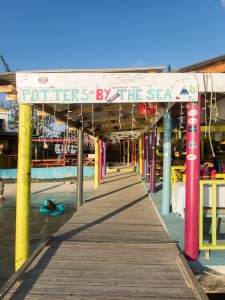
P5130064Our first night we had dinner at Potter’s. All of their business is from arriving boats.  They have a large dinghy dock, and no parking lot for cars. You have to place your order, either in person or by radio, by 6:00PM, and dinner is served at 8.  THE local speciality is lobster.  It is grilled over an open fire, and is smoky and delicious.  The decor is “customer decorated”.  It seems everybody who visits adds their own layer of graffiti to the walls.  Each restaurant along the beach has a large pen along side their dock where they store their lobster supply.  Some of them are HUGE.  The preferred bait in the traps is goat hide.

P5130061

Dinner on the hoof…

P5130068

The view from Potters Bar

Anagada is geographically quite distinct from the other islands in the area which are all high volcanic islands.  The highest point on Anagada is 23 feet above sea level.  It is surrounded by reefs which have claimed over 300 ships in the last couple hundred years.  At least one Spanish treasure galleon still hasn’t been found. Approaching Anagada we could see the turquoise color of the reef reflected on the bottom of the clouds long before we could see any trace of land. 

P5130046If you look VERY closely at this picture you can just pick out the land.  It is hard to see clearly in the photograph, but the undersides of the clouds over the shallow reefs (to the right in the picture) are a distinctly different color than those over deep water.

P5140090Our second day at Anagada, we sailed to the deeper water off the north side of the island to try to catch some pelagic fish.  We had no luck on the tuna or wahoo we were hoping for, but did well with Black Jack (a new fish to me, I had never even heard of it!) and Barracuda.

Tonight we are at the outskirts of one of the busy anchorages by Virgin Gorda, a “must stop” place for just about every charter boat working its way around the archipelago. Tomorrow we are going to the south side of Virgin Gorda, where the charter boats are not allowed to go, for a bit of piece and quiet.

Posted in Underway | Leave a comment