Catching up…

The weather for the past several days has been rather unsettled. Periodically windy (25 knots) periodically rainy–sometimes VERY heavy rain.  I have a bit of catching up to do with our adventures…

We did get a chance to do some fun snorkeling at Palmetto Bay.  It is an area with dense swarms of fish, but in the interior lagoon the coral growth is limited to a small election of gorgonians, and the ubiquitous fire coral.  The small cays had populations of the largest blue tangs I have ever seen, and a fair number of snapper and grouper.  The snapper and grouper have obviously been targeted by spearfishers, as soon as you get close, they dart into the nearest hole in the rock.

We took our time heading north, with a final destination of the island of Spanish Wells.  A large settlement where we knew we could replenish our provision lockers, which were getting a bit hollow after three weeks away from stores.

P5020083We sailed for a few hours each day, and anchored in the most protected spot we couple find overnight. The sailing was really fast, with the wind on our quarter, and blowing hard.  How fast?  Karen insisted that we grab a photo of our instrument display…
On a sailboat, 9 knots (10 miles per hour for you landlubbers) is really quite fast.  It always amazes me how effortlessly Harmonie moves even when she is galloping along.  To give you a feel for this, Harmonie’s 74 horsepower engine, at full throttle, moves her along at 8 knots.  To push that up to over 9 knots, the sails are generating well over 100 horsepower.

P5030111

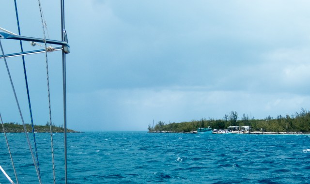
The final approach to Current Cut with heavy rain on the other side.

One of our challenges on this trip was the passage between the western most extension of Eleuthera, and Current Island, a narrow passage called Current Cut.  We managed to time our approach just right, so we did not have to deal with the raging tidal currents from which it gets its name, but it was still a very narrow passage with an approach characterized by shifting sand bars.

P5030107

Shallow over there… deep here.

The gusty winds and scattered downpours that greatly reduced visibility didn’t help.  It turned out to be an interesting, but uneventful passage.

Our final stop before the “big city” was one of the few harbors here with all round protection, Royal Island Harbor.  An island with no current signs of human activity, but prominent ruins.  We stayed in this harbor for two nights while the weather varied from calm to furious.

With a forecast for continued unsettled weather, we decided to take a marina slip to do our sightseeing and provisioning here.  Our initial impressions of Spanish Wells are very positive.  Stay tuned for more information!


Posted in Underway | Leave a comment

It really is a thing…

Honest.  You can Google it…

Fisherman’s Elbow.  It is basically the same as tennis elbow:  A repetitive motion injury of a particular tendon.  But I have it, and it is highly annoying.

In my case, it is either caused by, or exacerbated by, cranking a fishing reel.  If we are doing deep drop fishing, I do a LOT of cranking to recover close to 1000 feet of line.  If we are trolling, and catching fish, the recovery of the hooked fish is harder work. The problem is that so many tasks on the boat require the tight grip and pulling that irritate the body parts that are already inflamed.  Sigh. It looks like one of those things that heal very slowly…

We are anchored off of Palmetto Point on the west coast of Eleuthera.  Another one of the beautiful places.  There are a LOT of birds here, more than we have seen in other places in the Bahamas.  Franklins Gulls, Laughing Gulls, Oyster Catchers, Ospreys, several kinds of Doves, Caspian Terns, Kingfishers, Swallows, Coots, Mockingbirds, hummingbirds, and more…

On the sand flats here we saw a lot of lemon sharks cruising the shallows:

P4290010

Half a dozen sharks on patrol.

I also managed to spot several schools of bonefish.  Usually very skittish, these seemed OK with the boat drifting within five or ten yards… an easy cast….

Karen had a productive day shell gathering and exploring the beach of Pau Pau Cove.

P4290022_easyHDR-enhance

We’ll hopefully get a chance to do some snorkeling around the small cays tomorrow, and then we’ll head further north toward the more settled end of the island.

Posted in Underway | 1 Comment

Here it comes!

Some pictures from the southern end of Eleuthera:


Yesterday we left the beautiful pink sand beaches at East Point and we sailed around the southern end of Eleuthera, and north along its western facing coast.  A large shallow bank extends from here all the way to Nassau 65 miles to the east.  As usual, it was a delightful sail.

Since we were expecting some changeable weather, my initial choice was to head to Governors Harbor, one of the few places on this shore with good protection from most directions.  The cruising guide warned me off that, however suggesting that the anchor holding in the harbor was very poor.  So we grabbed something a bit more exposed,  but with deep sand for good holding, and we tucked as far back behind some small islands as we could.

Most of last night it stormed.  Strong winds, lots of lightening, and torrential rains.  Loud, and dramatic, but nothing scary.  By morning the weather had moderated, and we were down to some isolated showers.  We expected a breezy day, so our plans were basically to relax on the boat and wait to explore ashore tomorrow.

A bit after noon Karen was sitting topside and noticed the line of dark clouds approaching. The VERY dark clouds.  Not much later, we could see the approaching wall of rain and sea spray rapidly charging across the bay.  In less than a minute, it went from nearly calm to winds as strong as we have ever seen from the boat.  Neither of us had time to look at the wind speed gauge, but certainly over 45 knots.  With the first ferocious gusts, the boat slide about 50 feet back on the anchor, before it dug down deeper and we stopped.  We quickly ran into our anchor drag drill, but it turned out to not be needed.

Like many weather system of this sort, this one blew itself out pretty quickly, and left the outside of the boat well rinsed and the remainder of the day was beautiful.

P4280086

After the storm…

Posted in Underway | Leave a comment

Boarded!

We sailed out of Rock Sound this morning, for the deeper water just south of Eleuthera.  Once you get to the ocean, deep water is not far offshore.  I mean water is 2000 feet deep less than a half mile from shore.

We set our trolling lines about 10:30 or so.  We shared this part of the ocean with two other big sportfishing boats.  The targets for the boats fishing here are Mahi-mahi, Wahoo, Sailfish, and–if you are really lucky–marlin.

We saw one fish caught from one of the other boats, and then we spotted some frigate birds circling.  Around here, frigate birds follow the mahi.  The birds rely on the large predatory fish to chase the flying fish until they take to the air, where the frigate birds can pick they off on the wing.  (For some amazing video of this happening: https://www.youtube.com/watch?v=bk7McNUjWgw)

Sure enough, as we came by the area the birds were cruising, we hooked and landed a pair of mahi.  They are always welcome to come for dinner!  (I have pictures… but our internet connection here is not quite up to the upload…)

We traveled on to a delightful anchorage at the very southern tip of Eleuthera.  Just as we were getting into the dinghy to explore the beach, a large official looking boat hove to offshore, and a large RIB detaches itself and heads in our direction.  As it comes closer, we see the RBDF (Royal Bahamas Defense Force) logo prominently display on the side, and a crew of half a dozen smartly uniformed, and armed, young men.

They have a few questions, and politely ask if they can have a look around our boat.  A brief check of our cruising permit and passports, a cursory look around the interior of the boat, and they are off.  They were friendly, professional, and polite.

Posted in Underway | Leave a comment

Dealing with Two Watches

A man with one watch knows what time it is. A man with two watches is never sure.

So much of the art of seamanship (as opposed to the science) is sorting through and dealing with information that might be missing, or contradictory.  When you are the Captain there really is nobody else who can tell you what to do, it is your decision.

One example of this is in open ocean weather forecasting.  On our boat we typically get the results of four or five different weather models.  Almost all the time, for the next 24 or 48 hours the results are essentially the same.  Sometimes they do differ and you have to decide what to do.  I have actually seen people complain about having multiple sources of weather forecasts.  They want “someone” to give them ONE answer.

Another place where we get multiple sources of information is from our charts.  We have three sources that we use regularly.  Some of our detailed electronic charts come from a company called Navionics.  They are well known and one of the larger players in the industry.  They supply the chart data that is displayed on the screen at Harmonie‘s helm.

We also have a program on an iPad called iSailor that uses data from Transas, a Dutch company that mostly supplies chart data to commercial ships.  As far as I know the iSailor program is the only way for a recreational boater to get their data.

Finally, we use paper charts.  The source of these varies depending on where we are.  In the Bahamas and Caribbean we have been using NV Charts, published by a German company.

What we have found… in Florida, and in the Bahamas, there is no comparison. If the charts offer different versions of the truth, you should always bet AGAINST the Navionics chart.  The Transas data through iSailor has been, by far, the more accurate.  You might wonder what prompted this post…

We decided to sail from Little San Salvador over to Eleuthera.  Part of the reason we decided to do this was to go to Rock Sound where we would have better protection from winds that were going to be a bit variable in direction for the next few days. Based on the depths we saw from our Navionics charts, we expected Rock Sound to be shallow, but nothing we couldn’t handle.  (Reminder: we draw 6 feet 7 inches).  No depths reported on our route in less than 7.5 feet, and we will be there when the (rising) tide should have depths 8 to 12 inches deeper than shown.

Navionics Data Rock Harbour

Navionics data FAIL!

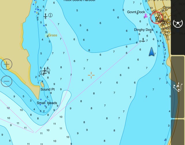
Well…  guess what… the ocean has not read the charts, or at least not the Navionics charts.  Let’s have a look at the depths reported by Transas in the same area…

Transas Data Rock Harbour

Transas nails it.

Based on this chart we’d expect to be just barely clearing the bottom at this stage of tide, and maybe touching a bit…  We bounced against the sandy bottom at least 5 times…  pretty much exactly where the Transas data would tell you we should.

This is not the first time we have found the Transas data significantly better than the Navionics.  In fact the only place we found Navionics better was one place where Transas showed “unsurveyed”.

What happened here?  Because the whole bay is charted just about a foot deeper than it really is, I’m betting the survey Navionics used was done at high tide and then not corrected for that fact.  In other places we see Navionics with bad data that is WILDLY improbable just to look at.  That tells me they do not have cartographers actually reviewing data, but just plug raw ugly garbage into an algorithm, and (surprise!) they get pretty garbage out.

But… all that drama and whining aside…  we are in Rock Harbour waiting for a convenient high tide so we can get out–without polishing the bottom of our keel.P4220006_easyHDR-default

Posted in Underway | 3 Comments

A day of catching…

Cat Island and Eleuthera are separated by 20 miles of deep ocean.  Most of it half a mile deep or more.  But… there is a narrow underwater “bridge” about 80 feet below the ocean that links these two islands.  With deep ocean water on both sides, steep drop-offs, and complex currents this is a place where fish large and small congregate, so of course it was the place for us to be today too… A short afternoon, and we had a king mackerel, and three different kinds of grouper in the boat.

We again saw roving schools of tuna tearing into bait, and managed to get a few strikes, but no hook-ups.

Tonight we are anchored out at Half Moon Bay off of the island of Little San Salvador.  It is a beautiful and quiet place most of the time, but a couple days a week the anchorage is crowded by several thousand other people, who all arrive on one boat…

P4180010

Half Moon Bay on a bad day…

I think tomorrow might be another fishing day…

Posted in Underway | Leave a comment

Cat Island

Lat: 24º 33.85’N
Long: 75º 38.84’W
Benett’s Harbor, Cat Island, Bahamas

We are anchored in the lee of Cat Island after a delightful sail down from Abaco.  As we approached through the narrow, but very deep cut of ocean that separates Cat Island from Eleuthera we were treated to the spectacle of a school of tuna feeding with the accompanying cloud of birds:  boobies, frigate birds, tropic birds, assorted terns…  We we a bit pressed for time to get to our anchorage approach before dark, or we would have stayed to see if we could pick off one or two…

_DSC4032

Tuna from below, and birds from above, making life very difficult for a bunch of little fish.

We’ll be headed back to the waters between Eleuthera and Cat Island to see what kind of tasty seafood we can bring onboard.

In the meantime we explored some of the tidal creeks here by dinghy.  What can I say?  It is just another one of the string of beautiful places we have had the pleasure of visiting. I was scoping out the creek as a possible place to hunt down some bonefish.  We didn’t see many… (OK, ONE!)

DSC_2453

Yes, it really is this pretty. Crowded too…

One downside to this island, is that there are very few places to anchor securely if the wind switches to blow from the west.  That’s not a concern for the next few days at least, but we do need to keep an eye on the forecasts.


Posted in Underway | Leave a comment

Goodbye to Abaco!

Time: 1320 local
Lat: 26° 20.1’ N
Log: 076° 47.3W

After several weeks bouncing around the Sea of Abaco, and enjoying all the many places we stopped there, we are off exploring again.

We are currently underway headed southeast toward Cat Island, one of the larger “Out Islands” of the Bahamas. It is a bit less settled, and a bit less visited, and the a reputation for great fishing.

Right now we are experiencing the very picture of “smooth sailing.” Deep reaching with reasonably steady 10 knots of wind, 4.5 knots of boat speed, and calm seas. We will be sailing overnight, and coming to an anchorage near our destination in the morning.

Posted in Underway | 1 Comment

Planning.

Weather here in the Bahamas is a mixture of Caribbean tropical and North American Temperate.  That means we get “normal” tradewinds blowing from a generally easterly direction, punctuated periodically by the tail ends of continental cold fronts.  In the 48 hours before a cold front approaches, the wind slowly clocks around from the east to the south west, usually increasing in slowly in strength.  Clouds thicken.  Rain starts suddenly, sometimes accompanied by thunder and lightening.  After a relatively short period of heavy rain, the wind switches suddenly to the north and blows hard for a few hours, then slowly tapers off as the rain fades away.  The wind continues it slow swing around the clock, and soon everything is back the way it started. These days it is all very predictable,  We know, for example, that a front will be passing through in the afternoon two days from now.

For boats anchored out here, this presents a challenge.  There are very few places here you can anchor which will give you protection from winds from all of those directions.  This means you have a couple of options. You can crowd into one of the few protected anchorages.  You can move the boat from one spot to another as the wind changes.  Or you can grab a slip in a marina.  For this frontal passage, we are going to wimp out and do the marina thing.  Once that passes, we are on the move again…

When the dinghy looks like this…

P4130014

….you know we have been grocery shopping. We are loaded up again for a trip a bit away from civilization for a while.  Here are our plans for the next few weeks.

We are heading about 120 miles southeast to Cat Island, hopefully to enjoy some of the great fishing there.  We will then be back up a little further north to Eleurthera to pick up my friend Alicia in mid May.  Then the last week in may we are joined by Alicia’s friend Annie and–with a full crew–we head north. We are really looking forward to an offshore passage with a crew full of sailors!

Where we will touch land on the east coast is still a bit up in the air.  But our ultimate goal is to get further north than we did last year, at least as far as Nova Scotia before the advancing winter chases us south again.


Posted in Underway | 2 Comments

We’re moving…

If you haven’t had the chance, go back to our previous post: Eat Snail  I have updated it with some fun photographs now that we are connected again…

Grand Cay

P4050028

Now THAT”S waterfront property!

P4050024

The Grand Cay waterfront.

P4050018

We have hooked WHAT?

Last night, we had settled in at a comfortable anchorage near Grand Cay in the Abacos.  Shallow water (8 feet), mostly clear sand bottom, breezy (15 to 18 knots) but not anything out of the ordinary.  The last thing we expected was a problem with the anchor .

As part of our normal bedtime routine, I set up the anchor alarm program on my phone.  A few minutes later, the alarm is sounding. Sure enough, we are dragging downwind.  Slowly, but definitely.  In the pitch black, before the moon rise, we get the anchor up and motor back to where we want to be.  Again we drop the anchor.  This time with a LOT of chain out.  At first, it looks good, but a gust of wind, and off we go again.  This is really strange.  I am beginning to have fantasies of replacing this anchor, forgetting that it has held us 199 times out of 200.

One more time, up the anchor comes.  After it clears the water, Karen gets a good look at it with the flashlight.  Ah-Ha!  Stuck on the point of the anchor is… an outboard motor! She manages to get the debris free, and this time the anchor sets down into the bottom like it was bolted down.

Now THAT’S a Wreck!

Off one of the tiny islands surrounding Grand Cay is a huge pile of metal.  From a distance it is not at all clear what it is, but close up, we could see it was the remains of a work barge.  The three tall pilings could be driven down into the bottom to lift the barge out of the water and provide a stable work platform for… whatever.  We haven’t had a chance yet to get the scoop from one of the locals, but a good guess is it was parked there

to ride out a hurricane…  which it didn’t.

An irony… googling the name of the barge–Jim Gibson–turns up a famous English photographer from the Cornish coast who specialized in… yep… shipwrecks.

Posted in Underway | 3 Comments